近几年地震频发,汶川大地震、海地大地震、智利大地震都对灾区造成了巨大的破坏。全球的强震活动引起了人们的广泛关注。事实上,根据专家的说法,地球每年平均发生约五百万次地震,人们能够感觉到的仅占1%。
众所周知,地震与地球板块运动有密切的关系,但你是否知道史前腕龙化石的发现竟然与板块构造学说有关联呢?板块运动又是如何改变地球面貌的呢?一起听听——
听力小提示:节目在中间和结束的地方分别提出了几个问题,同学们可以试着回答,检测自己是否听懂文章内容。
 More than 150 million years ago, during the Jurassic period[侏罗纪], Earth was nothing like it is today. The landscape was different, the climate was different, and the creatures that roamed[漫步] the Earth were very, very different.
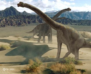
The Brachiosaurus[腕龙], or “Arm Lizard,” was one of many creatures that lived during this time. Brachiosaurus gets its name from its long forelegs, which looked a little like arms. It is one of the largest known animals ever to live on land. But until 100 years ago, we didn’t know anything about this dinosaur[恐龙]. In 1907, a German engineer was searching for minerals in eastern Africa when he stumbled on[无意中发现] thousands of bones of ancient creatures. Hundreds of people excavated[挖掘] this area, known as Tendaguru, near the coast of Tanzania in Africa, for five years. During that time they unearthed 250 tons of fossils[化石]. The fossils were sent to the Humboldt Museum in Germany. It took 20 years to sort and assemble[装配] the fossils before they were finally displayed. The most impressive find was one of the biggest, most complete skeleton[骨架] of a dinosaur ever found – the prehistoric Brachiosaurus.
Not only did this massive excavation effort uncover dinosaur fossils, it also unearthed a mystery. Thirty years earlier, bones of another Brachiosaurus had been dug up thousands of kilometers away in Colorado.
Scientists were baffled[困惑]. It was unlikely that two identical[同样的] creatures could have developed at the same time in two different parts of the world. And a dinosaur that lived on land could not have swum across the vast ocean between Africa and North America.
But what if that ocean had not always been there? What if Africa and North America had once been joined together in a single land mass[大陆块], so that Brachiosaurus could just walk from one part to another? Over the last 100 years, scientists have developed a theory that answers these questions and solves the mystery of Brachiosaurus.
The theory of plate tectonics[板块构造学说] revolutionized[彻底改革] our view of how the continents and oceans formed and changed over hundreds of millions of years.
Questions: How do you think that bones of the same type of dinosaur ended up in two distant parts of the world?
在一亿五千多万年前的侏罗纪时期,地球的样貌与现在大不相同。自然景观不同,气候迥异,漫步于地球之上的生物也非常非常不同。
腕龙,又名“长臂蜥蜴”,是生存于这一时期的其中一种生物。腕龙的名字来源于其长长的前腿——它们看起来有点像手臂。它是迄今所知体型最大的陆生动物之一。然而直到一百年前,我们还不知道这种恐龙的存在。1907年,一位德国工程师在非洲东部寻找矿石,无意中发现了许多远古生物的遗骨。成百上千人对这块位于非洲坦桑尼亚海岸附近、被称为“坦达古鲁”的地方展开了长达五年的挖掘。在此期间,他们挖起了250吨化石。这些化石被送往德国的洪堡博物馆。人们花了20年的时间对其进行分类和组装,才最终将它们展示于世人面前。而其中最令人印象深刻的发现要数一具迄今为止发现的最大、最完整的恐龙骨架——史前腕龙。
这项规模庞大的发掘工程不仅挖出了恐龙化石,还揭示了一个秘密。30年前,人们在数千公里外的(美国)科罗拉多州发掘出另一具腕龙骨骸。科学家们感到相当困惑。在同一时期,两只同种的生物似乎不太可能分别生长于两个不同的地方,而一只陆生恐龙也不可能游过非洲和北美洲之间的宽阔海域。
但如果这片海洋并不是一直都存在呢?如果非洲和北美洲曾经是一块连接在一起的单独大陆块,腕龙就可以从大陆块的一端走到另一端去,情况会怎样?在过去的一百多年里,科学家们提出一种理论来回答这些问题,并解开腕龙的秘密。
板块构造理论彻底改变了我们的认知,让我们认识到大陆和海洋在数亿年来是如何形成和演变的。
提问:同一种恐龙的骨骸最终散落于地球上相距甚远的两个地方,你对这个问题有什么看法?
The land masses on Earth were once very different from the way they are today. Earth’s surface is in constant[持续的] motion and the continents are no exception. They are part of tectonic plates that move about two or three centimeters a year, about as fast as our fingernails grow. Over millions of years new land masses are made, some relocate and others break up. The theory of plate tectonics explains how land masses move.
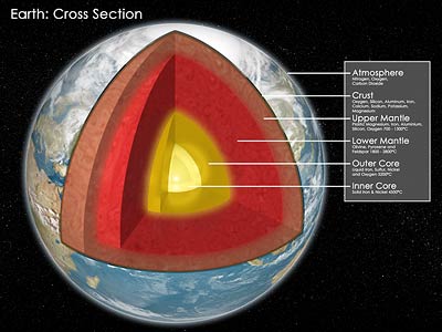
The Earth is like an egg: the yolk is the core, the white is the mantle[地幔], and the comparatively[相对地]thin shell is the Earth’s crust[地壳]. The top layer of the mantle together with the crust is called the lithosphere[岩石圈]. The lithosphere is broken up into about a dozen tectonic plates that hold all of the Earth’s continents and the ocean floor. The plates move continuously in response to[响应,反应]
slow-moving convection currents[对流循环气流] in the mantle. Land is pulled apart, shoved together, and reshaped. The theory of plate tectonics explains how it’s possible to find evidence of similar plants and animals, like the giant Brachiosaurus, on different continents.
Two hundred and fifty million years ago, the plates jammed together and formed one huge super-continent call Pangaea[泛大陆], which means “all land.” But over millions of years the huge continent split, and the modern continents gradually began to take shape.
Oceans too were created when Pangaea broke up. The Atlantic Ocean was formed when Africa and the Americas pulled apart. The giant continent of Pangaea is hard to imagine, but one look at the shore lines of Africa and South America makes it easy to see how they once fit together.
The boundaries between Earth’s tectonic plates are where all the action is. These cracks in the crust are called plate boundaries[板块边界] and most lie under the oceans. At the Mid-Ocean Ridge[山脊], molten magma[岩浆] rises from the mantle. When it cools, the magma makes new oceanic crust.
Plate boundaries both on land and under the water are also the places where most volcanoes form.
Some plate boundaries are visible on land, like the San Andreas Fault[断层] in California. The land around the fault is one of the most earthquake-prone[倾向于] areas on the planet. Here, plates try to move past each other and they sometimes get stuck. When they become unstuck, the movement that results is an earthquake.
When tectonic plates collide[碰撞], mountains may be created in the process. The Himalayas, Earth’s tallest mountain range, are relatively young. The collision between India and the Eurasian Plate pushed up these towering[高耸的] peaks only 30 million years ago.
The look of our planet is constantly changing. Brachiosaurus bones found continents apart have helped us understand Earth’s dramatic past.
Questions:What are Earth’s plates? How did plate movements affect Earth’s continents and oceans?
曾几何时,地球的大陆块与如今的样貌大相径庭。地球表面在不断运动,
大陆也不例外。它们都是构造板块的一部分。这些构造板块每年移动两至三厘米,和我们手指甲的生长速度差不多。经过数百万年,新的大陆块形成,有一些在迁移,另一些则裂开几块。板块构造理论解释了大陆块的移动。
地球就像一个鸡蛋:蛋黄是地核,蛋白是地幔,而相对较薄的蛋壳就是地壳。地幔的顶层和地壳被合称为“岩石圈”。岩石圈被分裂为十来个构造板块,承载着地球上所有的大陆和海床。这些板块随着在地幔中缓慢移动的对流循环气流而不断移动。陆地被拉开,推挤到一起,重新组合。构造板块理论解释了为什么会在不同的大陆找到相似的动植物的证据——如巨型腕龙。 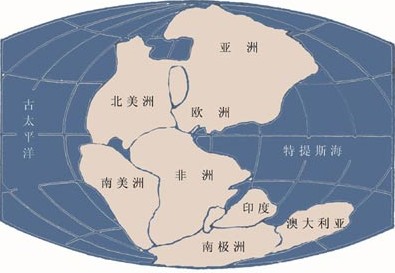 两亿五千万年前,各板块紧紧地挤在一起,形成了一块巨大的超级大陆,名为“泛大陆”(又称盘古大陆),意为“全部的陆地”。然而经历了数百万年,这块巨大的大陆分裂开来,现代的大陆逐渐成型。
当泛大陆分裂时,海洋也随之形成。
非洲和美洲被拉开,形成了大西洋。现在已经很难想象泛大陆是怎样一副模样,但只要看看非洲和南美洲的海岸线,我们就不难看出它们曾经紧密相连。
地球构造板块之间的边界是所有地壳运动发生的地方。这些地壳上的缝隙被称为板块边界,其中大多数位于海底。在海洋中脊,熔化的岩浆自地幔升起。冷却后,岩浆就形成了新的海洋地壳。
陆上或是水下的板块边界也是大多数火山形成的地方。
有一些板块边界在陆地上,清晰可见,比如(美国)加利福尼亚州的圣安德列亚斯断层。断层周围的地方是这个星球上地震最多发的地区之一。在这里,板块试图相互挤压,有时候会卡在一起。它们移动松开的结果就是地震。
当构造板块相互碰撞时,或许就会形成山脉。喜马拉雅山虽然是地球上最高的山脉,却还相对年轻。仅仅在三千万年前,印度板块与亚欧板块的碰撞推起了这些巍峨的山峰。
我们这个星球的外观在不断改变。在不同大陆上找到的腕龙骨骸帮助我们了解到地球过去完全不一样的面貌。
提问:什么是地球的板块?板块运动如何影响地球的大陆和海洋?